


A Recipe for a Photo Diagram
by Sarah Jane Jones, Alexandra Crosby and Ilaria Vanni
Here is an easy way to visualise commonalities and connections in urban ecologies. Photo diagramming can be used to follow plants, design neighbourhoods, recognise underground waterways, track movements of critters, and imagine multispecies futures.
Photo diagrams can also help read and analyse existing urban landscapes and the trajectories that constitute them.
Photo diagrams are a communication technique to reshuffle our relations with place and the environment and inspire us to take action in our everyday lives.
10 Steps to Photo Diagramming your Neighbourhood
Acknowledge first nations people. If you are in Australia, what Country are you on? Country is the term often used by Aboriginal peoples to describe the lands, waterways and seas to which they are connected. Country includes complex ideas about law, place, custom, language, spiritual belief, cultural practice, material sustenance, family and identity. If you are not in Australia, what people have lived on the land you are now on?
Start where you are. Sit on the ground. Try to answer these questions: What can a photograph do? What can a drawing do? What might be beneficial about combining these types of images?
Go for a walk, taking as many photographs as you can. What do you notice? Did you see any other humans? What other species did you notice? How did they interact?
Repeat. The more walks you do, the more photographs you take, the better your photo diagram will be.
Look at your photographs. This is your place-based archive of more-than-human images. Well done.
Sort your photographs. Let categories emerge as a way of organising what you have seen. You can use tags or folders, albums on your phone or post it notes to sort your images.
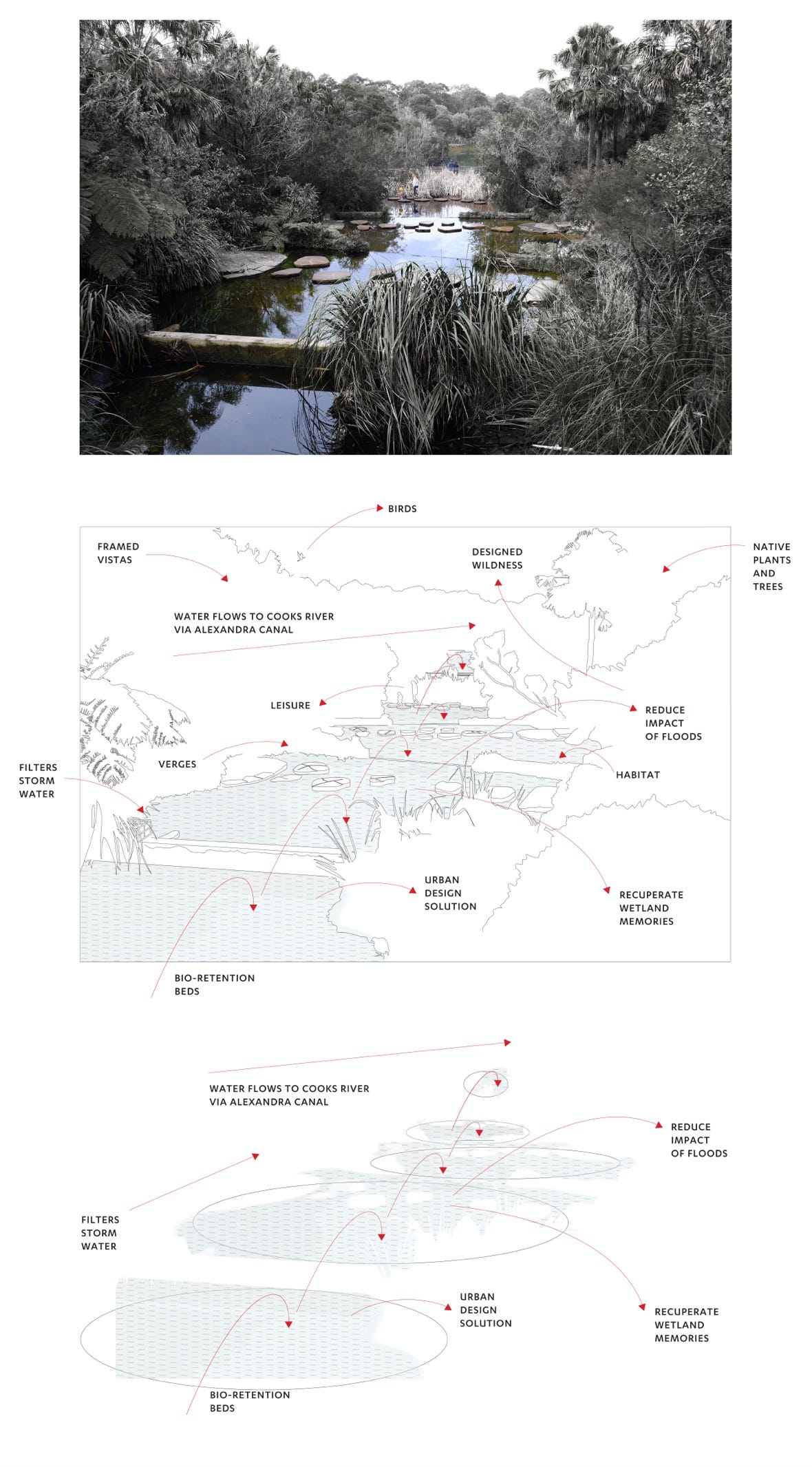
Label your categories. Be poetic. Your words matter: critters; infrastructure; leisure; plants; trees; water flow, insects, moss, soil, rubbish, picturesque elements.
Take a rest. From memory, or by looking at your new more-than-human archive of images, choose one scene that stands out. A scene is everything you can see and hear from one point standing still.
Draw this scene, using the photograph as a reference. Trace a diagram, highlighting certain aspects, using arrows and line drawings to further enhance the leading elements of the image. Use the categories you made to label the diagram
Take somebody on a walk in the same place and share your diagram with them. What have you found out? What did they find out?
References and Further Reading:
Jones, Sarah Jane, et al. “From Photo Documentation to Photo Diagrams: A Technique to Make Civic Ecologies Present and Legible.” Visual Communication, May 2024, p. 14703572231218418. DOI.org (Crossref), https://doi.org/10.1177/14703572231218418.
https://aiatsis.gov.au/explore/welcome-country
©
Sarah Jane Jones, University of Technology Sydney, is a lecturer in Visual Communication. She examines ways to incorporate storytelling into urban wayfinding design – central to this is exploring the relationship between physical signage and digital wayfinding.
Alexandra Crosby, University of Technology Sydney, researches more than-human design and urban ecologies.
Ilaria Vanni, University of Technology Sydney, is a transdisciplinary researcher across social sciences and design as transformative fields of research and practice. She works with Alexandra Crosby as Mapping Edges Research Studio.